When it comes to flying, navigating is everything. That's where drones with GPS really shine. Imagine being able to effortlessly track your drone's position in real time. No more worrying about losing sight of it or having it drift away. With GPS technology, you can enjoy amazing peace of mind while exploring the skies.
These drones come packed with features that take the stress out of piloting. For instance, many models offer return-to-home functionality. If your battery gets low or you lose connection, your drone will automatically fly back to where it took off. It's like having a built-in safety net!
Plus, GPS allows for precise flight planning. You can set specific waypoints for your drone to follow, letting it fly a predetermined route. This is fantastic for aerial photography or surveying land because you get consistent, repeatable shots or data collection each time. No more guesswork; just set it and let it do the hard work for you.
With drones equipped with GPS, you can also enjoy geofencing. This feature helps keep your drone within a designated area. If you’re in a busy place or near restricted airspace, geofencing keeps your flight safe and within legal limits. It adds another layer of security, which is crucial for beginners and seasoned pilots alike.
Real-Time Tracking for Safety
Real-time tracking is a game changer when it comes to safety with drones. Drones with GPS technology let you keep tabs on your drone's location as it flies. This means you won't lose sight of it, even if it's zooming out of your line of sight. Whether you’re using it for photography, surveying, or just for fun, knowing exactly where your drone is at all times brings peace of mind.
If something goes wrong, like a low battery or a technical hiccup, you don’t have to panic. With GPS, you can quickly get your drone back. Most systems show you the path your drone took so you can easily guide it back to you. It's like having a built-in safety net—just in case things don’t go as planned.
It’s also helpful in situations where you want to monitor the drone's flight in active environments like construction sites or wildlife observations. Knowing the drone's exact position helps avoid accidents and keeps everyone safe. Plus, you can set up virtual boundaries, so the drone won’t fly too far without a clear command from you. This added level of control makes drones with GPS a must-have for responsible operators.
So if safety is high on your list, consider investing in drones with GPS. They not only enhance your flying experience but also ensure that you have a reliable companion in the sky. You'll enjoy flying without the constant worry of losing track of your drone or the trouble of retrieving it when it goes off course.
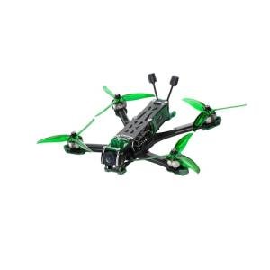
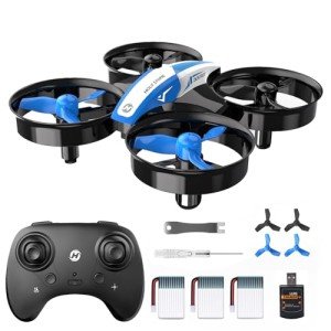
GEPRC MARK5 O4 Pro FPV Drone with GPS
Experience top-notch flying with the GEPRC MARK5 O4 Pro, packed with GPS and ready for your next adventure
Product information
$661.99
Product Review Score
4.67 out of 5 stars
127 reviewsProduct links
Accurate Location Data for Your Projects
When you're taking on a project that requires precision, having accurate location data makes a world of difference. Drones with GPS technology offer just that. They provide detailed geolocation information that can elevate your work to new heights. Whether you’re mapping out a construction site or monitoring crops, these drones deliver the exact coordinates you need.
With Drones with GPS, you can easily gather data from hard-to-reach areas. No more guesswork! The GPS will guide your drone, ensuring it flies exactly where you need it to go. Plus, many of these drones can create real-time maps and 3D models as they fly, giving you visuals that help in decision-making.
The benefits don’t stop there. GPS-equipped drones can set waypoints for repeated flights, allowing for consistent data collection over time. This is crucial when you're tracking changes in a landscape or measuring growth in agricultural fields. You get reliable updates without the hassle of redoing flights.
Also, the integration of GPS lets you monitor your drone's location at all times, so you don’t have to worry about losing it in the field. Knowing where your drone is can give you peace of mind, especially during lengthy missions.
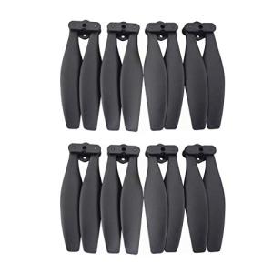
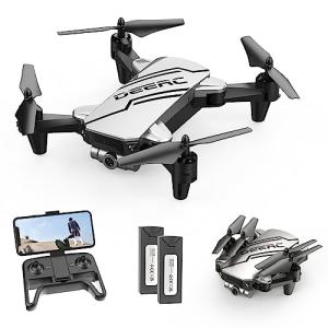
8-Pack Replacement Propellers for U38 U39 Drones
Keep your U38 and U39 drones flying high with these durable replacement propellers
Product information
$17.99
Product Review Score
4.7 out of 5 stars
188 reviewsProduct links
Easy Mapping and Surveying Solutions
Drones with GPS technology take mapping and surveying to a whole new level. They make it super easy for professionals in fields like construction, agriculture, and real estate to gather accurate data quickly. Gone are the days of using bulky equipment and spending hours in the field. Now, you can fly a drone over vast areas and get precise measurements with minimal effort.
Thanks to GPS, these drones can create detailed maps and 3D models in no time. You simply set your flight path, and the drone handles the rest. The data collected is accurate and reliable, which means you can make decisions based on solid information. Plus, you can access this data on your computer or smartphone, so everything is right at your fingertips.
If you’re looking to streamline your workflow, drones with GPS are a game-changer. They save you money and time, reducing the need for manual surveys that can take days. Whether you're trying to analyze land for a new project or gather information on crop health, these drones provide insights that help you work smarter, not harder.
And let's not forget about the fun factor! Flying a drone is an enjoyable experience. You get to see everything from a bird's-eye view, and it feels like you’re commanding your own little aircraft. So, if you're considering investing in mapping and surveying tools, drones with GPS technology should definitely be at the top of your list!